If you are looking for a place to go trekking in Golfo Aranci and experience 'wild' adventures on the north-eastern coast of Sardinia, you will find a unique environment that combines unspoilt landscapes and authentic nature experiences. Famous for its crystal-clear waters and biodiversity, the area offers activities such as dolphin spotting, sailing around the islands of Tavolara and Molara, kayaking, water-biking, boat trips, and trekking suitable for all levels. In addition to white sandy beaches and hidden coves, there are hills covered with Mediterranean scrub, impressive cliffs and breathtaking mountain views. Several areas have free parking, making it easy to choose between nature walks or boat trips. In this article, we propose some must-do trekking itineraries in Golfo Aranci, with details on difficulty, equipment and curiosities, to fully experience all that Golfo Aranci has to offer.
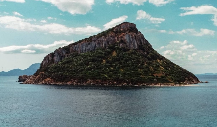
Cape Figari: the magic of the land

The flora is typical of the Mediterranean area, with a predominance of myrtle, mastic tree, strawberry tree and juniper.
While trekking in Golfo Aranci, it is not uncommon to smell the intense perfume of these plants, mingling with the salty sea air.
The fauna is equally rich: it is possible to spot cormorants, herring gulls and, with a bit of luck, even dolphins that regularly frequent the waters of Golfo Aranci.
All that remains is to pack your backpack and venture into the trekking trails in Golfo Aranci.
Trekking in Golfo Aranci: those not to be missed
Trekking: Mount Ruju
Starting from the entrance of Cala Moresca or the Sentiero dei Carbonai, the Sentiero Monte Ruju is a short but fascinating trekking experience in Golfo Aranci.<br
Along an easy and accessible route, the slight initial slope invites you to immerse yourself in the beauty of the Mediterranean scrub, with cysts, filasche, wild olive trees, strawberry trees and small junipers dotting the route.
If you are lucky, you might even hear the rare call of the Peregrine Falcon flying over the area.
This idyllic spot, surrounded by a natural green meadow, is perfect for a relaxing break.
From here, following the only signpost, the route becomes more challenging and adventurous. But the reward is worth the effort: the ascent will give you a breathtaking panorama of the village of Golfo Aranci, with a unique view from about 200 metres above sea level. A short itinerary, but one capable of leaving indelible memories!
If you are a lover of hiking off the beaten track, the Mount Ruju is a must-see destination on your list. Located above Golfo Aranci this peak offers a breathtaking panorama.
Before setting off, it is useful to know that the way to the summit is not marked on maps of Komoot.
The marked path ends about 100 metres below the summit, leaving you the opportunity to improvise the last stretch. From there, a small, barely visible path will guide you to the summit. It is here that the hike becomes a little more adventurous: the terrain becomes rustic and the undergrowth thick, so long trousers are highly recommended to protect you from branches and shrubs. Following the path, you will have to go around the rock on the left and then tackle the climb from the back. Fear not: no climbing or technical equipment is necessary. Those with some mountain experience will find this section within reach. However, the last part is rather steep and requires sure-footedness and attention.
Route statistics
Difficulty: T (suitable for all)
Length: 620 m
Journey time: 30 minutes
Suitable for: FOOTBALL - BIKE
Place of arrival
The summit of the Mount Ruju offers a 360-degree view that sweeps from the sea to the surrounding hills, giving you a truly unforgettable sea breeze that will engage your senses.
Capo Figari: trekking on the Cala Moresca panoramic trail
The trek starts from Cala Moresca winds its way along the promontory, passing several viewpoints and places of historical interest, such as the Luigi Serra Battery and the Traffic lights at Capo Figari and then return along the same route. The total length of the route is approx. 8 km (there and back) with a height difference of 350 metres. Being a linear scenic route, those who wish to shorten the hike can turn back at any time.
If you are looking for a hike that combines nature, history and unforgettable views, trekking in Cape Figari with its 342 metres high is a unique experience to live. A scenic path leads past enchanting beaches, hidden coves and typical Mediterranean scrubland, among junipers and scented bushes.
Along the trail you will come across wonderful sites:
Luigi Serra Battery
The Luigi Serra Battery is a historic military post built during the Second World War. This strategically positioned structure was part of the Italian coastal defence system and was used to guard the Gulf of Olbia and the surrounding sea routes. Today, the battery is an attractive place for history and trekking enthusiasts, thanks to its panoramic location that offers spectacular views of the sea and the surrounding coastline, and is also an excellent place for photography enthusiasts. Although in a state of abandonment, the site retains the charm of ancient military fortifications and is an excursion destination for those wishing to explore a piece of the past surrounded by nature.
English Cemetery
The English Cemetery is a place steeped in history, silence and mystery, telling fragments of broken lives and maritime legends. This fascinating place is home to 13 burial mounds, an irregular stone pyramid, and a tombstone from 1891 dedicated to five shipwrecked sailors recovered in 1887. The atmosphere is unique: a small granite altar with a statue of the Madonna and juniper crosses pay tribute to the missing sailors. Granite seats and a rusty anchor complete this corner of memory and serenity, perfect for reflection and immersion in local history.
Among the most emblematic tombs is that of George Christian Bradshaw, a young British sailor from the ship H.M.S. Vulcan who died tragically in 1900 at the age of 18.
The Military Semaphore of Cape Figari
From this fascinating place, Guglielmo Marconi, on 11 August 1932, launched the first transcontinental radio signal, connecting Rocca di Papa, near Rome, to the yacht Elettra anchored offshore.
Today the building is in a state of abandonment, but its historical value and the 360° panorama it offers make it an extraordinary stop. From here you can admire the majestic island of Tavolara, which seems to emerge from the water in all its grandeur. At the end of the excursion, weather permitting, you can refresh yourself with a swim at Cala Moresca with its turquoise waters that will be the perfect ending to a day that mixes adventure, culture and relaxation. An unmissable excursion for those who want to discover the most authentic Sardinia!
Route statistics
Distanza 12,6 km
Technical difficulty Medium
Altitudine massima 262 m
Route type Ring
Place of arrival
The Cape Figari lighthouse, located in 342 metres above sea level offers a unique spectacle of the protected marina: a view of the island of Tavolara and the beautiful blue waters of the Tyrrhenian Sea.
Trekking in Golfo Aranci: for enthusiasts
Trekking: ring of Cala Sabina
The Cala Sabina loop trail is one of the most fascinating and relaxing experiences one can have in Golfo Aranci. This route starts near the roundabout of the village and runs along the coast, offering spectacular views of the crystal-clear Sardinian sea. The path, although unmarked, is clearly visible and suitable even for the less experienced. As you walk along the path, you will be immersed in the typical Mediterranean maquis, with junipers, cysts, mastic trees and strawberry trees filling the air with characteristic scents.
A highlight of this trek is the possibility of discovering several hidden coves surrounded by granite rocks and transparent water. The beaches along the route are perfect for a short break: you can take a regenerating swim or simply admire the breathtaking landscape. In some stretches, you can see the island of Tavolara dominating the horizon, creating a unique backdrop for photography enthusiasts. With a minimal height difference, this hike is ideal for families, birdwatchers or anyone who wants a pleasant, immersive walk in nature.
Route statistics
- Difficulty level: T (Tourist)
- Length: 9.09 km
- Walking time: Approximately 2 hours 30 minutes
- Suitable for: FEET
Place of arrival
The loop concludes by returning to the starting point, offering spectacular views of the Gulf of Olbia and the imposing island of Tavolara. Along the way, there is no shortage of perfect spots to sit and enjoy the view in peace.
Trekking: the Mouflon Trail
To undertake this trail, it is necessary to be accompanied by an experienced guide, as the route is classified as difficult EE (Experienced Hikers) and has rough and rugged stretches.
The departure generally takes place near Cala Moresca.
To reach Cala Moresca, it is advisable to park your car in the free 'Baracconi' car park and walk along the pedestrian area leading to the cove.
At the entrance to the trail, an information board with a detailed map provides useful information on the route. The route is marked in yellow.
This yellow-marked itinerary will take you to one of Sardinia's most authentic and unspoilt territories. The starting point is located near Cala Moresca, an enchanting bay with turquoise waters, surrounded by maritime pines that provide shade and refreshment.
The path passes through dense Mediterranean scrub, consisting of mastic trees, junipers, wild olive trees and cysts, and offers many opportunities to spot the local fauna. Mouflons, the reserve's iconic animals, are often visible as they move among the limestone rocks and meadows. In addition to the mouflons, it is possible to spot birds of prey such as the peregrine falcon, which majestically flies over the area, and to listen to the songs of numerous bird species.
The route is characterised by panoramic stretches offering spectacular views of the Gulf of Olbia, Figarolo Island and the imposing Tavolara, which emerges from the sea like an island fortress. Although it is classified as a route for experienced hikers (EE), it does not require any special technical equipment, but a good sure-footedness to tackle the steepest and most irregular sections.
Route statistics
- Difficulty: EE (Experienced Hikers)
- Length: 2.5 km
- Walking time: Approximately 1 hour 30 minutes
- Suitable for: FEET
Place of arrival
The route culminates in extraordinary viewpoints, including a natural terrace offering unparalleled views of the cliffs of Cape Figari and the turquoise sea below.
A perfect place to go trekking in Golfo Aranci and enjoy the silence and wild beauty of Sardinia.
Trekking: the Coalmen's Path
To undertake the Coalmen's Path in Golfo Aranci, it is advisable to park your car in the free car park located in front of the Town Hall in Via Libertà.
From there, continue on foot along Via Guglielmo Marconi.
After passing a small railway overpass, turn right; after a few metres you will find an information board marking the entrance to the Capo Figari SCI (Site of Community Importance) area, the starting point of the path.
The Sentiero dei Carbonai (charcoal burners' path) runs along the western slope of the promontory, offering a series of ascents and descents, some of them quite challenging, along the ridge of Mount Ruju overlooking the sea.The Sentiero dei Carbonai is a historical route that crosses the Capo Figari Natural Area, offering a unique experience for trekking and nature lovers. This itinerary immerses itself in the lush Mediterranean maquis, among forests of centuries-old junipers and wild olive trees, and offers numerous opportunities to spot local fauna, such as mouflons and peregrine falcons. The name of the route recalls its ancient function: in the past, coal miners used these routes to transport the coal produced in the forests of Capo Figari.
Along the path, you will come across places of unique charm, such as panoramic terraces overlooking the sea. These vantage points allow you to admire the Gulf of Olbia and the Island of Tavolara in all their beauty. The rich and fragrant vegetation creates a multi-sensory experience that will remain etched in the memory.
The trail is well-marked and with a moderate difference in altitude, perfect for walkers of all levels, from beginners to experts. It is advisable to wear hiking shoes and carry a water bottle, especially during the warmer months. There are information signs and maps along the route, which make the hike easy to follow.
Route statistics
- Difficulty: E (Hiking)
- Length: approx. 6 km
- Walking time: Approx. 2 hours
- Suitable for: FEET, BIKES
Place of arrival
The route culminates at an extraordinary vantage point offering a spectacular view of the sea and the striking rock formations of Cape Figari. The panorama is particularly impressive at sunset, when the sky is tinged with warm colours and the sea reflects golden hues.
General advice
What to wear
- Hiking shoes with good grip
- Windbreaker (the wind at the top can be strong)
- Trekking poles for greater stability
What to bring
- Route map or GPS app
- Torch (if you plan to return at dusk)
- Snacks and water
What to put in your backpack:
- Water bottles (especially essential during the summer months)
- Energy snacks or dried fruit
- Sun cream and insect repellent
- Hat and sunglasses
- First aid kit
Frequently asked questions
Which excursions are most suitable for families?
The most family-friendly walks are undoubtedly those that lead to the path to Cala Moresca.
Can I take my dog on hikes?
Yes, many trails are pet-friendly. However, you should always carry water for your dog and keep him on a leash for safety.
What is the best time to go trekking?
Trekking is possible all year round, although the ideal period is spring and autumn, due to the pleasant mild temperatures that these seasons bring to the Sardinian territory.
Are there refreshment points along the trails?
No, it is important to take water and snacks with you, as the trails do not have refreshment points.
Do you need special permits to access the trails?
No, all the described routes are accessible free of charge and do not require special permits.